

Meet the Airo-Sight Team
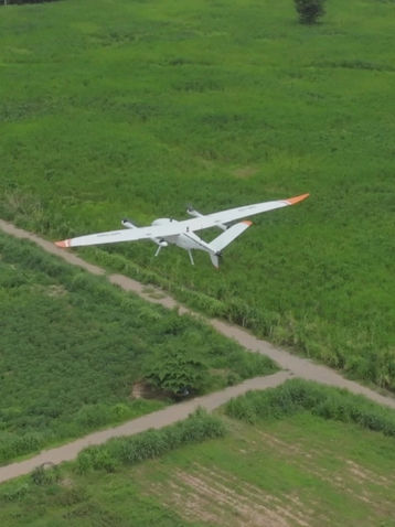
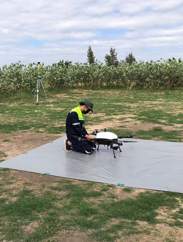
The Airosight team, managed by ICS, consists of UAV service specialists covering a wide range of applications, from general photography and drone videography to highly specialized tasks. They provide both 2D and 3D imaging solutions, offering efficiency and convenience for various projects, such as rapid mapping, architectural structure analysis, building damage inspection, and progress reporting through aerial drone photography


Service Process
.webp)
บินสำรวจ ทำแผนที่ความละเอียดสูง
(Aerial Mapping)
Aerial mapping flights differ from standard aerial photography. Mapping flights capture comprehensive data, including the size, elevation, and detailed features of the terrain. This allows accurate measurement of area, volume, and distances, facilitating better design and planning for land use and development.
Data Obtained from Aerial Mapping Flights
-
High-Resolution Orthomosaic Maps: Enable accurate measurement of area and dimensions.
-
Digital Surface Model (DSM): Provides information on the elevation of various surfaces.
-
Digital Terrain Model (DTM): Provides information on the elevation of the terrain.
-
3D Point Cloud: Enables the creation of 3D models, which can also be used for 3D printing.

Example of LiDAR Mapping Processing

หาค่าปริมาตรกองวัสดุด้วยโดรน
(UAV Volume Estimation)
Drone-Based Material Stockpile Volume Measurement Service to measure the volume of various material stockpiles, such as soil, sand, coal, wood chips, and more. It is particularly suitable for stockpiles located outdoors or in open areas. Our team conducts drone flights to collect data on the stockpiles, which is then processed to calculate their volume and generate detailed reports for each stockpile being measured.
Data Obtained from Aerial Surveys
-
Point Cloud of Buildings and Material Stockpiles: Provides detailed 3D data of structures and measured stockpiles.
-
Volume of Stockpiles or Weight: Can be calculated when bulk density is known.
-
Usage Comparison: Enables monitoring of material consumption and remaining quantities in continuous or routine measurements.

หาค่าปริมาตรกองวัสดุด้วยเทคโนโลยี Lidar
(LiDAR Volume estimation)
Volume Measurement of Material Stockpiles Using 3D LIDAR Scanning Technology This service utilizes LIDAR technology to create a 3D point cloud, which is then processed to calculate the volume or weight of bulk materials. It is suitable for measuring various types of bulk stockpiles, including wood chips, shredded wood, bark, bagasse, coal, ores, chemical and organic fertilizers, construction materials such as rocks, soil, sand, and other bulk materials. Measurements can be conducted both indoors and outdoors.
Measurements can be conducted quickly and with high accuracy, helping to significantly reduce costs and enhance warehouse management capabilities.
Data Obtained from 3D LIDAR Scanning
Point Cloud of Buildings and Stockpiles: Provides detailed 3D data of the structures and measured stockpiles.
Volume or Weight of Stockpiles: Can be calculated when bulk density is known.
Usage Comparison: Enables monitoring of material consumption and remaining quantities in continuous or routine measurements.
Highlights from the Mission

ตรวจวัดคาร์บอนเครดิต
(LiDAR Carbon Credits Surveying)
LiDAR Carbon Credits Surveying Service Using LiDAR this service can quickly and accurately scan trees to determine their height and circumference without the need to measure each tree individually. The Airosight team employs a handheld LiDAR device, which allows scanning of forested areas to create 3D models of surrounding trees. The collected data is then processed in post-processing to extract the necessary information for carbon credit calculations
For areas larger than 50 rai, drones are used to map the area, identify the number of trees, and classify all plant species within the site. Data from both handheld LiDAR scans and drone surveys are then combined to assess carbon credits.
Results:
-
A report detailing the number of trees, their heights, and species for carbon credit calculation.
-
A 3D model of the surveyed area.
-
In cases where drones are used, additional high-resolution aerial images of the area are provided.
ความเห็นจากลูกค้า
ทีมงานดูมีความเป็นมืออาชีพ สามารถทำงานได้ลุล่วงตามกำหนดเวลา ข้อมูลที่ได้รับจากการบินสำรวจเอาไปใช้งานได้จริง ช่วยประหยัดเวลาและค่าใช้จ่ายที่ไม่จำเป็น
Bangkok
ความเห็นจากลูกค้า
" ทาง Airsosight มีระบบสำรองข้อมูลให้กับลูกค้า ตอนที่เผลอทำข้อมูลหาย จึงรีบแจ้งทีมสนับสนุนไป ดีใจมากที่ไม่ถึงสัปดาห์ ทางทีมก็สามารถกู้คืนข้อมูลให้ได้อย่างครบถ้วน "
Pitiwat P.
Chiang Rai
ความเห็นจากลูกค้า
"ดีครับ มีบริการ Maintenance ภายในประเทศด้วย ส่งเคลมง่าย
ไม่ต้องส่งของไป-กลับต่างประเทศ สะดวกมาก"
Natdanai P.
Udon Thani


โมเดลสิ่งก่อสร้าง 3มิติ
(Point Cloud 3D Model)
The creation of 3D computer graphics models depends on the number of surface points required for proper rendering. Multidimensional points provide the computer with the necessary data to digitally construct physical objects in a three-dimensional plane. Points associated with specific shapes, images, or other graphics are defined by X, Y, and Z coordinates. All coordinates related to the image are collectively referred to as a point cloud, which represents all the points that describe the outer surface of a 3D object.


Results of 3D Modeling
-
Construction Design Visualization: 3D modeling allows architects and engineers to see the entire structure and simulate additional elements.
-
Base 3D Model for Digital Twin: The model can be used as a foundation for creating digital twins for both interior and exterior building applications.
-
3D City Mapping: Enables mapping of urban buildings in 3D, classifying them into nine types for Smart City projects and taxation purposes.
-
Integration with AI: Facilitates easy inspection of building damage, including cracks on high-rise structures.
-
Enhanced Presentation: 3D modeling improves project presentations, helping clients better visualize the construction.
-
Error Reduction in Construction: Using 3D models during design stages makes it easier to identify and correct potential errors.
-
Improved Staff Understanding: 3D models help staff visualize projects clearly, enhancing construction and detail management efficiency.
-
Data Sharing and Real Estate Promotion: External building visuals from 3D models can be shared for marketing and promotion of real estate projects.


